Profile trasy
Gdy dostępne są informacje o wysokości, można znaleźć wysokość lub wysokość oraz profil nachylenia, przewijając w dół na ekranie szczegółów trasa. Gdy dostępne są informacje o czasie, możesz również znaleźć profil prędkości i odległości na ekranie szczegółów trasa. Podczas nagrywania trasa można dotknąć linii trasa zarejestrowanej trasa, aby otworzyć ekran nagrywania. Znajdziesz tam również wysokość i profil prędkości. Podczas planowania trasa lub generowania trasa można dotknąć etykiety „Całkowita wysokość”, aby zobaczyć profile wysokości i nachylenia planowanej trasa. Może być konieczne przewijanie w dół na ekranie szczegółów trasa, aby zobaczyć wszystkie profile.
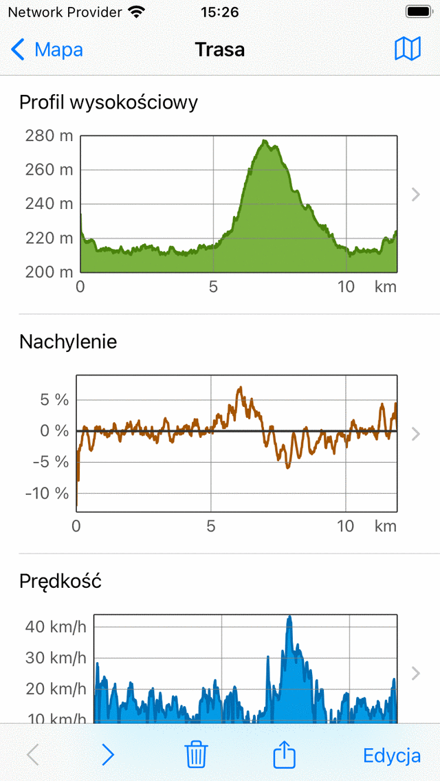
Przykład profili wysokości, nachylenia i prędkości w ekranie szczegółów trasa.
Profile Wysokość
Zarówno wysokość, jak i profil elewacji są profilami wysokości. Wysokość to wysokość urządzenia w stosunku do średniego poziomu morza. Wysokość to wysokość gruntu w stosunku do średniego poziomu morza i najczęściej pochodzi z cyfrowego modelu elewacji. Jeśli ktoś idzie po ziemi, wysokość jest w przybliżeniu równa wysokości. Ale jeśli ktoś leci, wysokość i wysokość są różne. Profile wysokości zarejestrowanych trasy w Topo GPS są zawsze profilami wysokości, tj. mierzonymi za pomocą GPS i barometru (jeśli są dostępne).
Profil nachylenia
Profil nachylenia pozwala szybko spojrzeć na trudność trasa. Procent nachylenia (zwany również stopniem) to wielkość przemieszczenia pionowego w porównaniu z przemieszczeniem poziomym. Chociaż profil nachylenia może się znacznie zmieniać, gatunek najbardziej stromych części można łatwo znaleźć na z profilu nachylenia. A także długość najbardziej stromych części można szybko odczytać. Wraz z długością i całkowitym wzniesieniem daje to szybkie wyobrażenie o trudności trasa.
Radzimy dowiedzieć się, jakie stoki możesz sobie poradzić. Możesz to zrobić, badając wykresy nachylenia trasy nagrane wcześniej. Następnie zawsze sprawdzaj wykres nachylenia, zanim zechcesz śledzić trasą. Jeśli ma strome części na dłuższych dystansach, które są powyżej twoich możliwości, lepiej wybierz inną trasę do podążania.
W profilu nachylenia w Topo GPS stoki obliczane są między punktami oddalonymi z siebie o około 200 m, aby wygładzić fluktuacje.
Profil Prędkość
Profil prędkości daje szybki przegląd prędkości trasa. Ten profil jest dostępny tylko wtedy, gdy trasa została zarejestrowana.
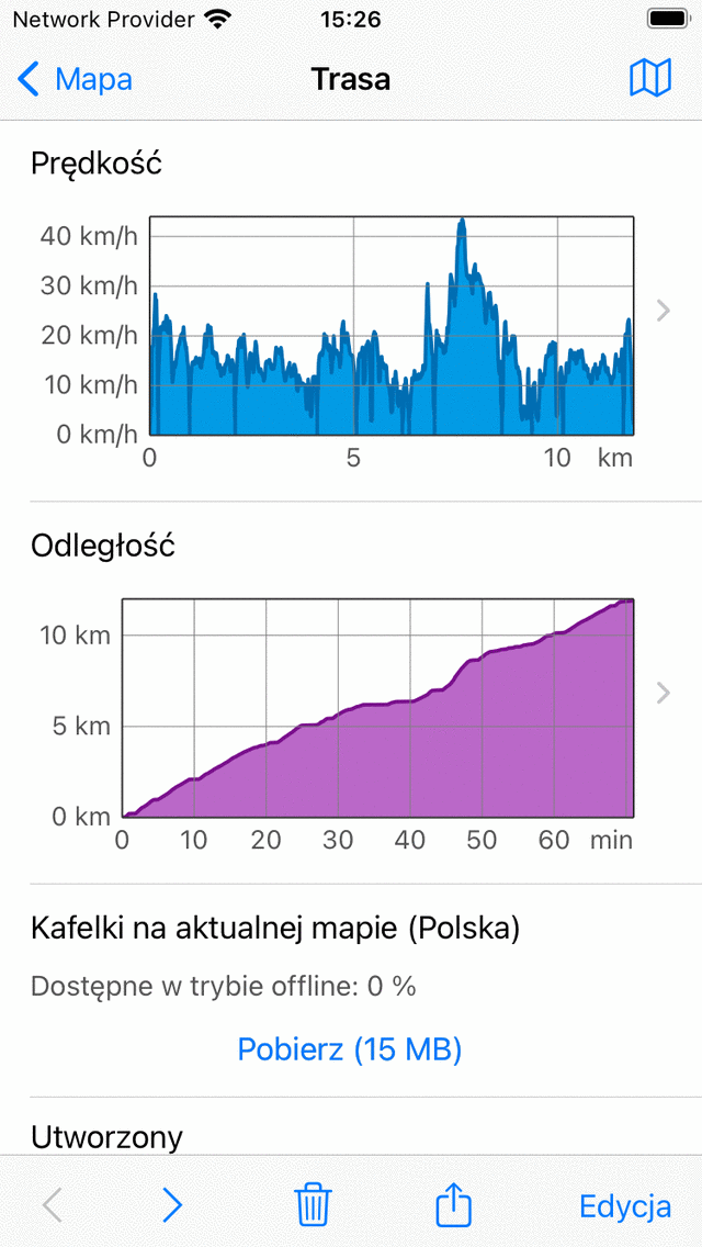
Przykład profili prędkości i odległości na ekranie szczegółów trasa.
Profil Odległość
Profil odległości daje przegląd, w jaki sposób przebyta odległość wzrosła wraz z upływem czasu. Ten profil jest dostępny tylko wtedy, gdy trasa została zarejestrowana.
Ekran profilu
Możesz dotknąć profilu w ekranie szczegółów tr asa, aby otworzyć ekran profilu. Poniżej omawiamy tylko ekran profilu wysokości, inne profile pokazują inne informacje, ale ich ekrany profili działają podobnie.
Przykład ekranu profilu wysokości pokazano na poniższym rysunku:
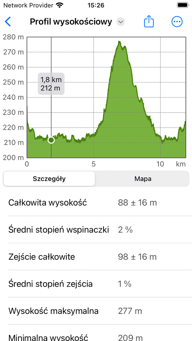
Profil wysokościowy trasa bardziej szczegółowo
Ekran profilu wysokości zawiera wykres i informacje. Wykres zawiera wskaźnik, który można przeciągnąć, aby odczytać wartość z profilu. Kładąc dwa palce na profilu i odsuwając je z siebie, możesz powiększyć profil, aby zobaczyć więcej szczegółów. Jeśli masz powiększenie, możesz również przesunąć profil jednym palcem. Aby pomniejszyć, połóż dwa palce na profilu i przesuń je do siebie.
Na dół możesz wybierać między kartami „Szczegóły” i „Mapa”. W powyższym przykładzie otwierana jest karta „Szczegóły”. Daje to szczegółowe informacje na temat profilu wysokości, takie jak „Całkowita wysokość”, „Średni stopień wznoszenia” i „Zejście całkowite spadek”.
Jeśli wybierzesz zakładkę „Mapa”, mapa trasa zostanie wyświetlona w połączeniu z profilem wysokości, jak widać w poniższym przykładzie:
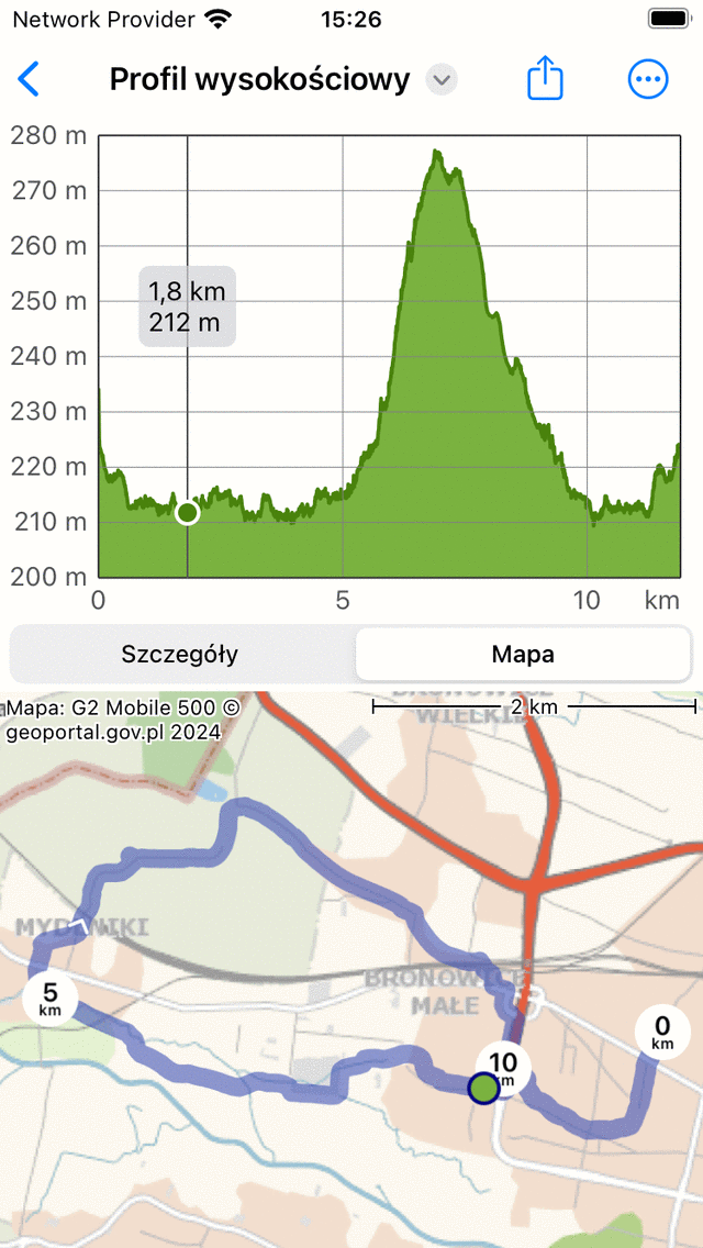
Profil wysokościowy trasa z mapą trasa
Pozycja wskaźnika na wykresie jest pokazana zielonym punktem na mapie. Jeśli przeciągniesz zielony punkt wzdłuż trasa, wskaźnik w profilu wysokości również się przesunie. W ten sposób można łatwo znaleźć interesujące punkty w profilu wysokości na mapie.
Jeśli dotkniesz ikona „Więcej” w prawym górnym rogu ekranu, możesz zmienić oś poziomą. Możesz wybierać między „Odległość”, „Czas trwania” i „Czas”.
Jeśli dotkniesz ikona eksportu u top ekranu, możesz wyeksportować i udostępnić profil w formacie PDF.
Jeśli dotkniesz tytułu „Wysokość” u top ekranu, możesz szybko zmienić profil na inny typ, na przykład profil nachylenia lub profil prędkości.
Całkowita wysokość i zejście
Całkowite wzniesienie to skumulowany wzrost wysokości trasa. Alternatywnie, jest to suma wszystkich pionowych przesunięć w górę. Podobnie całkowite zejście to skumulowana utrata wysokości trasa lub suma wszystkich pionowych przesunięć w dół. Całkowite wzniesienie trasa jest pokazane na ekranie szczegółów trasa, w sekcji tytułowej tuż pod mapą. Również całkowite wzniesienie i całkowite zejście można znaleźć na ekranie profilu wysokości.
Zwłaszcza całkowite wzniesienie daje wraz z długością i profilem nachylenia wyobrażenie o trudności trasa. Trasy o większym całkowitym wzniesieniu są zazwyczaj trudniejsze.
Teoretycznie całkowite wzniesienie i zejście są dość proste do zrozumienia. Załóżmy na przykład, że rozpoczynasz trasę na wysokości 100 m. Najpierw idziesz na wzgórze ścieżką o długości 1 km do wysokości 150 m. Następnie idziesz 2 km w dół do wysokości 120 m. Całkowite wejście jest w tym przykładzie (150 - 100) m = 50 m. Całkowite zejście wynosi (150 - 120) m = 30 m.
W praktyce obliczenie całkowitego wzniesienia/zejścia nagrane trasa jest trudniejsze. Trasa z wysokościami jest w rzeczywistości zbiorem punkty, z których wszystkie mają swoje błędy pomiarowe. Gdybyśmy po prostu zsumowali wszystkie dodatnie zyski pionowe, uwzględnilibyśmy również fluktacje pomiarowe, co skutkuje nieuzasadnionym duży wzrostem całkowitym. Dlatego szacujemy dokładność określania wysokości w Topo GPS i używamy go jako odcięcia dla uwzględnienia zysków w całkowitym wzroście. W praktyce oznacza to w przybliżeniu, że zyski są uwzględniane w całkowitym wzroście tylko wtedy, gdy zysk wynosi co najmniej około 10 m. Obliczamy również błąd. Dlatego całkowite wzniesienie jest przedstawiane jako wartość ± błąd. Jeśli wartość całkowitego wzniesienia wynosi na przykład 320 m ± 50 m należy odczytać ją jako, najprawdopodobniej całkowite wzniesienie wynosi od 270 m do 370 m.
W rzeczywistości inne programy/aplikacje będą inaczej obliczać całkowite wzniesienie, a zatem mogą podawać wartości, które mogą różnić się (znacznie) z Topo GPS. Dlatego najlepiej porównać całkowite wzniesienia między trasami tylko wtedy, gdy są obliczane w ten sam sposób. Możesz więc doskonale porównać całkowite wzniesienie trasy A w Topo GPS z trasą B w Topo GPS. Jednak bądź ostrożny, jeśli porównać całkowite wzniesienie trasy A w Topo GPS z Trasa A w innej aplikacji.