Rozszerzenie wysokości
Możliwe jest rozszerzenie Topo GPS z przedłużeniem wysokości. Ten dodatek pozwala wykonać następujące czynności:
Wyświetlanie wysokości terenu (elewacji) na panelu współrzędnych deski rozdzielczej.
Wygener uj szybkie profile wysokości za pomocą linijki mapy.
Wygener uj profile wysokości dla trasy zaplanowanych za pomocą środków transportowych wrona lecieć.
Wygener uj dokładniejsze profile wysokości dla wszystkich zaplanowany trasy.
Wygeneruj profile wysokości dla trasy, które nie mają profilu wysokości.
Pokaż wysokość nad ziemią i wysokość nad profilami podłogowymi.
Coverage
„Rozszerzenie wysokości” jest płatnym dodatkiem i obecnie dostępne tylko w Niemcy, Anglii, Walii, Francja, Szwajcarii, Austrii, Holandii, Belgii i Luksemburg. W przyszłości będziemy dodawać kolejne regiony. Jeśli kupisz teraz Rozszerzenie wysokości, otrzymasz również dostęp do regionów, które zostaną dodane w przyszłości.
Zakup rozszerzenie wysokości
Aby zakupić rozszerzenie wysokości, powiększ mapę do jednego z regionów, w których rozszerzenie wysokości jest dostępne. Następnie przesuń deskę rozdzielczą dwukrotnie lewa, aby wyświetlić panel współrzędnych. Następnie dotknij panelu współrzędnych i wybierz „Pokaż wysokość” w wyświetlonym wyskakującym okienku. Następnie pojawi się ekran zakupu.
Wyświetlanie wysokości terenu
Do wyświetlić wysokość terenu w metrach nad poziomem morza określonego punktu, musisz dwukrotnie przesunąć deskę rozdzielczą lewa, aby otworzyć panel współrzędnych. Następnie wysokość terenu (elewacja) punktu wskazanego krzyżem w środku mapy zostanie wyświetlona obok współrzędnych, jak w poniższym przykładzie:
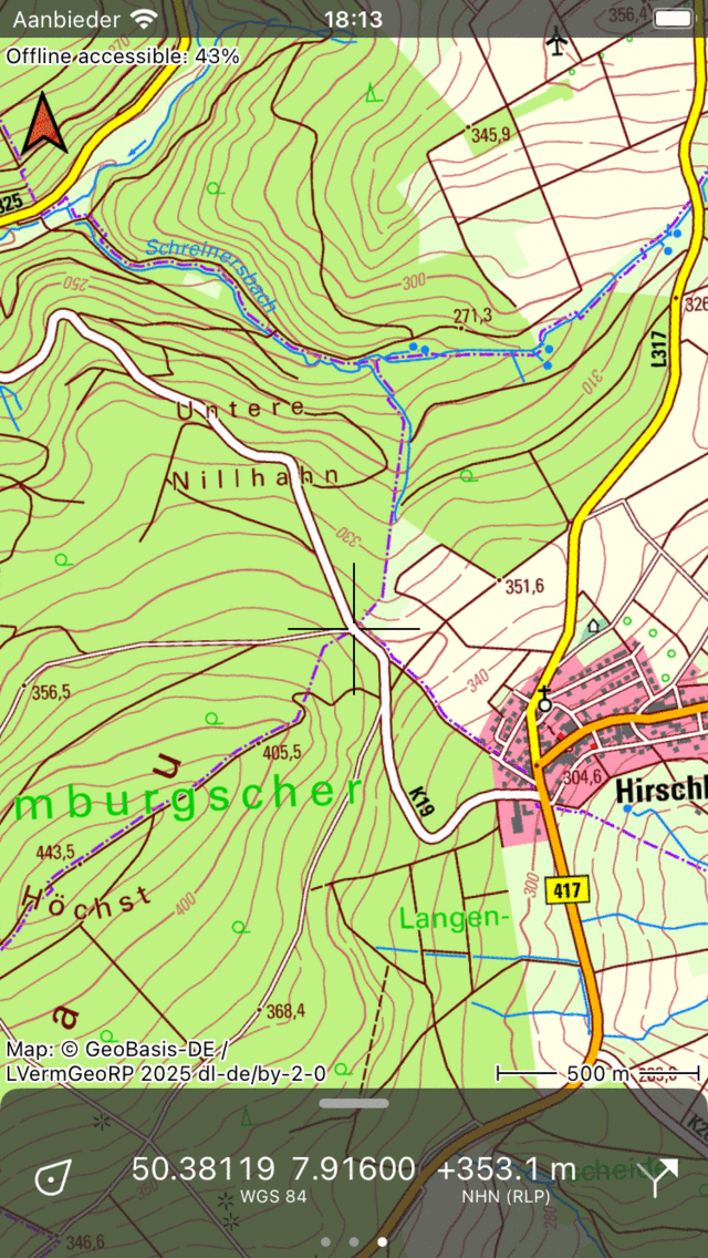
Wysokość terenu jest pokazana obok współrzędnych na desce rozdzielczej.
Możesz dotknąć wysokości, aby wyświetlić szczegóły dotyczące źródła, odniesienia pionowego i dokładności. Musisz powiększyć mapę wystarczająco daleko w regionie, w którym dostępne jest rozszerzenie Wysokość, aby wyświetlić wysokość terenu.
Jeśli dotkniesz znacznika pozycji, możesz wyświetlić wysokość terenu obecne stanowisko.
Jeśli dotkniesz punktu, wysokość terenu punktu zostanie wyświetlona tuż poniżej współrzędnych na ekranie szczegółów punkt trasy.
Profile szybkiej wysokości
Do szybko uzyskać profil wysokości wzdłuż linii prostej, musisz aktywować linijkę mapy. Naciśnij długo na mapie, aby pojawiła się ikona tworzenia punkt trasy, a następnie dodaj drugi palec, aby aktywować linijkę. Jeśli linijka mapy znajduje się w zakrytym obszarze, a linijka jest wystarczająco długa, obok ikony krzyża zamykającego pojawi się ikona profilu wysokości. Jeśli dotkniesz ikona profilu wysokości, profil zostanie wyświetlony w górnej części ekranu. Jest to profil wysokości wzdłuż linii linijki mapy.
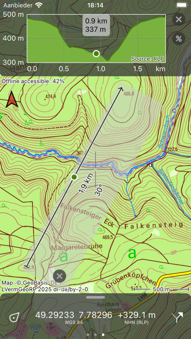
Profil wysokości jest generowany przy użyciu linijki mapy.
Jeśli przesuniesz linijkę mapy lub zmienisz jej rozmiar, profil wysokości zostanie natychmiast zaktualizowany. Aby odczytać wysokość, można przeciągnąć punkt w oknie profilu wysokości. Punkt jest również przedstawiony na linijce mapy, dzięki czemu można łatwo zobaczyć położenie punktu w profilu wysokości na mapie.
Możesz powiększać i pomniejszać profil, kładąc dwa palce na oknie profilu i odsuwając je z siebie lub do siebie.
Jeśli dotkniesz ikona procentowej obok profilu, zostanie wygenerowany profil nachylenia. W zależności od jednostek nachylenia ustawionych w ustawieniach Topo GPS wyświetlany jest procent nachylenia lub kąt nachylenia. Pozwala szybko zobaczyć, jak stroma jest pewna linia.
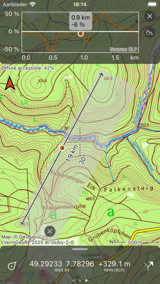
Profil nachylenia jest generowany przy użyciu linijki mapy.
Profile Wysokość tras planowanych z wykorzystaniem lot wron
Jeśli nie aktywowałeś rozszerzenie wysokości, trasy zaplanowane w trybie transportu lot wron mucha nie będą miały profilu wysokości. Zakup rozszerzenie wysokości gwarantuje, że trasy plan owane za pomocą środka transportu „Lot wron fly” automatycznie uzyskają profil wysokości, gdy trasa znajdzie się w zadas zonym obszarze Rozszerzenie wysokości. Przykład pokazano w poniższym rysunku:

W raz z rozszerzenie wysokości planowane trasy muchy wrony uzyskają profil wysokości.
W przykładzie planowana jest Lot wron. Na dół wyświetlane jest całkowite wzniesienie wzdłuż trasa. Jeśli dotkniesz całkowitego wznoszenia, zostanie wyświetlony profil wysokości.
Dokładniejsze profile wysokości dla zaplanowany trasy
Informacje o wysokości użyte w przedłużaniu wysokości oparte są na bardzo dokładnych cyfrowych modelach terenu, uzyskanych przez skanowanie laserowe terenu przez samoloty. Dokładność pionowa i pozioma jest znacznie wyższa niż w danych wysokości używanych w planerze trasa bez rozszerzenie wysokości. Jeśli kupiłeś rozszerzenie wysokości, profile wysokości będą oparte na dokładnych cyfrowych modelach terenu. W rezultacie obliczona kwota całkowitego wznoszenia będzie również dokładniejsza.
Wygeneruj profili wysokości dla trasy, które nie mają profilu wysokości
Jeśli zaimportowano trasę, na której brakuje trasa, profil wysokości zostanie automatycznie wygenerowany po otwarciu ekranu szczegółów trasa. Jeśli trasa jest długa, być może będziesz musiał dotknąć przycisku „Generuj profil wysokości”. Może minąć trochę czasu, zanim pojawi się profil wysokości, ponieważ czasami najpierw trzeba pobrać informacje o wysokości.
Wygeneruj profili wysokości terenu dla zarejestrowanych trasy
Jeśli zarejestrowałeś trasę, wysokość jest określana przez GPS i/lub barometr urządzenia. Czasami uzyskane w ten sposób dane wysokości są dość niedokładne, z ogromnymi wahaniami. W związku z tym na ekranie szczegółów trasa wyświetlamy również profil wysokości terenu poniżej profilu wysokości odtworzonej. Ten profil wysokości terenu może być bardziej użyteczny i dawać bardziej wiarygodne oszacowanie całkowitego wzniesienia. Jednak czasami profil wysokości terenu bardzo różni się z rzeczywistego profilu, na przykład gdy ktoś przechodzi przez most nad doliną. Most ten zostanie uwzględniony w zarejestrowanym profilu wysokości, ale nie w profilu wysokości terenu, który odpowiada kształtowi doliny.
Wysokość nad ziemią
Zwłaszcza gdy jesteś w powietrzu, interesujące może być oszacowanie wysokości w stosunku do ziemi. Wysokość z GPS (wysokość) to wysokość w stosunku do średniego poziomu morza. Jeśli odejmiesz z tego wysokość terenu, otrzymasz wysokość nad ziemią. Jeśli dotkniesz znacznika pozycji, możesz wyświetlić bieżącą wysokość nad ziemią.
Jeśli zarejestrowałeś trasę, możesz wyświetlić profil wysokości nad ziemią na ekranie szczegółów trasa. Jeśli trasa jest powietrzna, wysokość nad profilem naziemnym jest już wymieniona poniżej profilu wysokości terenu. Jeśli nie, możesz dotknąć profilu wysokości, aby wyświetlić szczegóły profilu, a następnie w górnej części ekranu możesz przełączyć widok profilu na wysokość nad ziemią.
Szczegóły techniczne przedłużenia rozszerzenie wysokości
Pobieranie
Informacje o wysokości są przechowywane w płytkach o wymiarach 4 km x 4 km. Płytki te muszą zostać pobrane z naszego serwera i będą przechowywane na Twoim urządzeniu. Możesz pobrać informacje o wysokości określonego regionu, dotykając opcji „Dostępne w trybie offline” w lewym górnym rogu ekranu, aby otworzyć ekran pobierania mapy. Następnie przewiń w dół do sekcji „Modele Wysokość”. Tutaj możesz dotknąć „Pobierz”, aby pobrać modele wysokości dla aktualnie widocznego regionu. Można również usunąć modele wysokości, aby odzyskać miejsce do przechowywania.
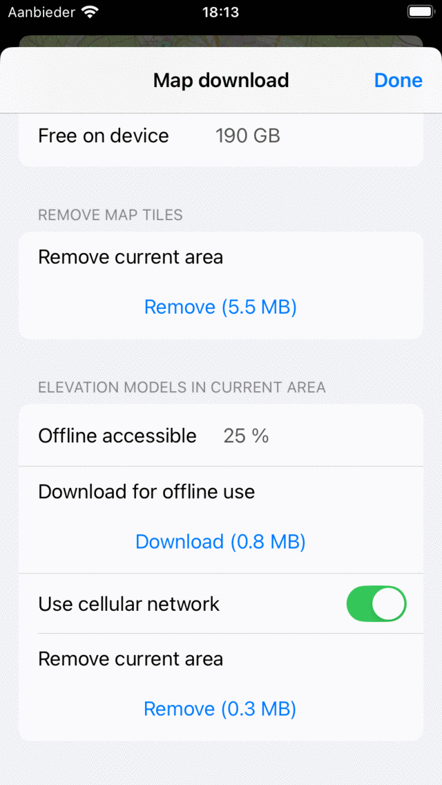
Po bieranie cyfrowych modeli wysokości do użytku offline.
Jeśli modele wysokości zostały udostępnione w trybie offline, możesz przeglądać wysokości i generować profile bez połączenia z Internetem. Możesz to przetestować, tymczasowo przełączając urządzenie w tryb samolotowy z wyłączonym Wi-Fi.
Dokładność
Wysokości w przedłużeniu wysokości uzyskuje się z cyfrowych modeli terenu. Są to bardzo dokładne duże zbiory danych, w których wysokość określa się zwykle co 1 m za pomocą lasera z samolotu. W oryginalnym zbiorze danych wysokości są dokładne do około 0,1 m, jednak nieco zmniejszyliśmy dokładność w wyrafinowany sposób, aby uzyskać rozmiar danych, którym można zarządzać w aplikacji. Nasza deklarowana dokładność to: 95% wysokości różni się mniej niż 0,5 m z pierwotnego pomiaru. Jest to idealna dokładność do zajęć na świeżym powietrzu, nie każdy guz jest zauważalny, ale mała nasypy są.
Prywatność
Do określić wysokość za pomocą przedłużenia Wysokość, najpierw określa się niezbędną płytkę wysokości 4 km x 4 km. Jeśli kafelek nie jest przechowywany na Twoim urządzeniu, jest automatycznie pobierany z naszego serwera. Następnie wysokość jest określana na z tej płytki wysokości na urządzeniu. Nigdy nie zostaną wysłane żadne współrzędne na nasz serwer. rozszerzenie wysokości jest bardzo przyjazne dla prywatności, i tak nie możemy wyświetlić pozycji twoich punkty lub trasy, jeśli określisz wysokość lub profil wysokości.